 Light rail provides high volume transit at all times of operation, but light rail in mixed-use traffic lanes subjects trains to delay as trains are stuck behind motor vehicle traffic, not infrequently for long periods when the traffic lane is a right turn or left turn lane and motor vehicles clear very slowly due to pedestrian volume and cross-street congestion.
On the other hand, dedicated transit lanes allow light rail vehicles to proceed, reducing travel times and conflicts. Transit lanes can be for rail only, and narrower (10 feet), or can be for all transit vehicles including buses, and wider (11-12 feet, or 13 with a buffer).
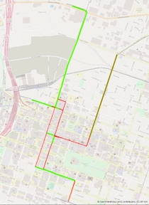
The map at right (and available at a pdf) shows the light rail aligment in downtown Sacramento. The green lines are dedicated transit lanes, while the red lines are mixed-traffic lanes. The Green Line from G St to Township 9 station is a single track, dedicated lane, separated in various ways from the general purpose traffic lanes. The Gold Line from 8th and 7th Streets to Sacramento Valley Station, is a single track, dedicated lane. The short section of Blue Line between 7th St and 8th St is single track (westbound) on a pedestrian plaza. The combined Blue Line/Gold Line between 7th St and 12th St is a double track on pedestrian plazas and closed portions of street. The Blue Line on 12th St between J St and North B St (and beyond, but not shown on this map) is a mixed traffic lane southbound and a dedicated lane northbound.
Not shown on this map are six bus routes that use sections of 7th and 8th Streets (51, 15, 2, 6, 11 and 34).
Future posts will look at each of these segments and suggest improvements that could be made to speed light rail and reduce congestion.
Next up: Grid 3.0
