
The City of Sacramento’s preliminary master plan documents for Sacramento Valley Station have some detail but are to varying degrees conceptual. Two diagrams from the city’s presentation slides (there are several presentation documents but they have similar graphic content) are offered below. These diagrams are NOT the ones used in the survey.
The Transit Network diagram shows the circulation patten for trains (blue), light rail (light green), streetcar (dark green), buses (purple), private cars (red) and bicycles (orange). This is the only diagram that shows all the modes, except walking, on one sheet. The bus plaza, just south of the train tracks, with buses entering from 3rd Street and exiting to F Street is very prominent on this diagram, but not shown on several others, and not shown on any of the survey diagrams. 3rd Street does not currently extend into the project area, so this would be a significant change, with the streetcar tracks following this alignment. The bus exit along F Street adds to light rail double track and a bicycle facility, rather a lot to squeeze into this narrow underpass. H Street would be open to traffic to 3rd Street, but if isn’t clear whether this would be through traffic. As shown on other diagrams, there is an effort to recreate the street grid within the limits imposed by physical barriers such as the freeway and train tracks.
It is concerning that pedestrians are nowhere to be found on this diagram. How will people walking in from various directions manage to reach the area? Will they have multiple safe crossings of routes used light rail, streetcar, buses, private vehicles, and bicycles?
![]()
The Station Circulation diagram below shows how all the modes are actually connected, with an elevated concourse well above ground. The detail not shown at this conceptual level is how the two levels will be connected. Stairs, ramps, escalators, elevators? If ADA compliant and user friendly elevators are offered at each point, that’s a lot of elevators. No matter what direction a person is coming from, what transportation modes they are connecting, she will have to ascend and then descend. There will be no across-platform transfers. Other diagrams indicate the existing tunnel will be used only for service needs, not by the public.
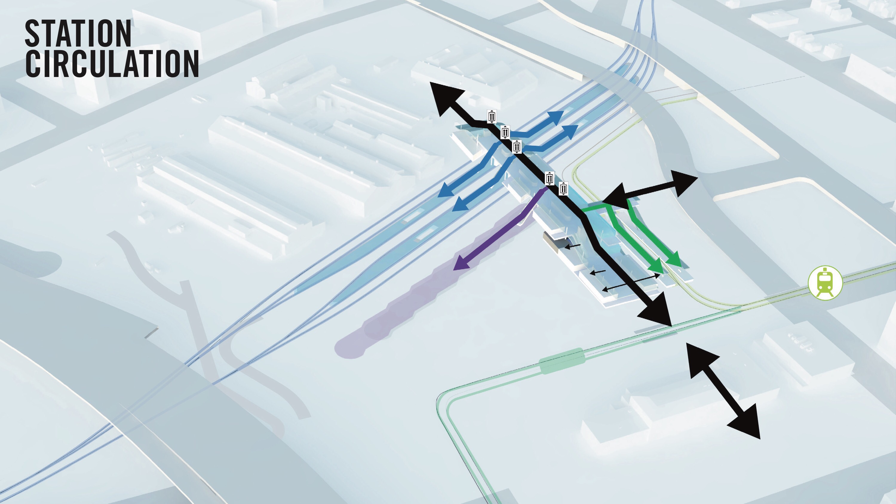
These two diagrams are Option 1 from the presentations. Option 2, below, varies largely in that there is a concourse rather than ground level drop-off area, the concourse is a different shape, and buses exit to 3rd Street rather than F Street.
![]()
In common to these and all other diagrams is that the historic train station will not have any transportation function remaining. The new concourse would contain all the transportation functions as well as retail.
Depending on the transfer being made, some distances are a long as the current station to platform distance, particularly for the bus area. Will there be shuttles, will there be moving walkways? How will riders who are not specifically handicapped but have difficulty walking long distances be assisted?
The elevated concourse idea was first proposed, so far as we know, for the eventual high speed rail connection to Sacramento. But that connection is 20 or more years away. Without high speed rail funds, will the city have the funds to build this major concourse structure, with transportation and retail areas, and multiple sets of long ramps and/or escalators, elevators, stairs? More importantly, can any of these connections work before the final configuration is built out? STAR is concerned. As we have expressed before, across-platform connections are optimal, whether temporarily or permanently. These designs do not offer across-platform.
