Transit Oriented Development (TOD) is a great concept. Place the development where it can benefit from transit service rather than being in a transit desert, remote from functional transit. I (Dan Allison) have been re-reading/reading Walkable City by Jeff Speck. Step 4: Let Transit Work (page 139 of the 10th anniversary edition) has a section ‘Its the Neighborhoods, Stupid’. The point is that dropping transit or housing into a neighborhood that is not already walkable and bikeable, or quickly evolving to be so, is a waste of limited resources. He says “Neighborhood structure refers to the presence or absence of real neighborhoods, which are technically defined as being compact, diverse, and walkable. A true neighborhood has a center and an edge, and contains a wide variety of activities in close proximity within an armature of pedestrian-friendly streets and and public spaces.”
The City of Sacramento has had a TOD ordinance for several years (2018 and 2020), and TOD plans for light rail stations as well. State law now makes development around transit much easier, similar to earlier city efforts.
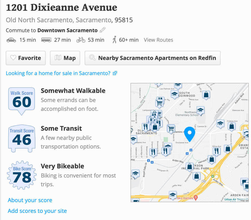
My concern is that decisions about where to locate transit oriented development won’t be based on the locations with the highest return, for development, for transit, for livability. As an example, there is the Swanston Station Plan Transit Village Plan. Note that this plan is from 2007 and would likely look different if it were written today, but it is still a valid plan with the city and SacRT. It is unlikely that you have gotten on or off light rail at Swanston. Almost no one does. On a typical weekday, there are about five cars parked in the lot, with 311 free spaces. There is no bus service here, because there are no riders. This is a dead station. Few people would feel comfortable being here, unless immediately dropped off or picked up by someone in a car.
Of course redevelopment of a huge empty parking lot at the station is appealing, with the land already in the public domain, but development without a neighborhood is not a good investment.
Below is the WalkScore for the station area. There are certainly worse places in the city, but there are also much, much better. Note that WalkScore is a measure of the number of amenities within walking (or bicycling or transit) distance; it is not a measure of actual walkability because it doesn’t assess sidewalk presence or absence, or condition. There may be something close, but if there isn’t a sidewalk, no one is going to walk there.
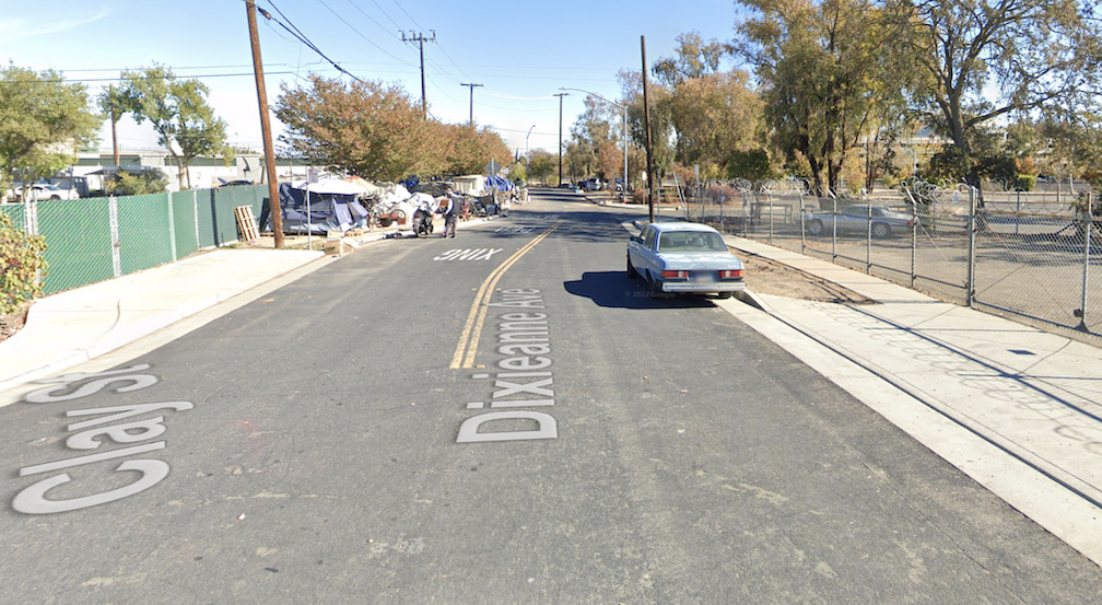
So, is this a good location for transit oriented development? Below is the approach to Swanston Station from Dixieanne. There is a sidewalk, but no bike lane. The area is surrounded by empty lots, parking lots, car repair, warehouses, and low density mobile home parks. Because the station is essentially unused, it has become an encampment for unhoused people. Dixeanne west of this location has received some walking improvements, and even in a few places, street trees to shade the sidewalk.
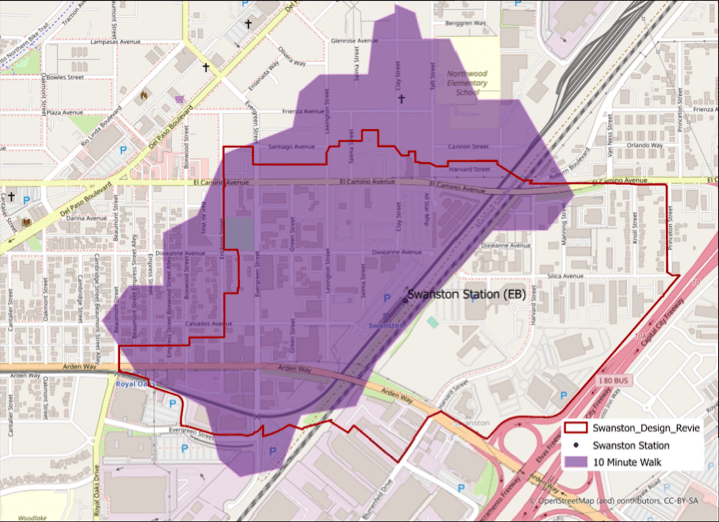
The ten minute (about one-half mile) walk shed for Swanston Station is shown below (pdf). Note that there is essentially no access to the southeast side of the light rail and freight tracks, and about half of the plan’s Design Review Area. The plan proposes a bridge to the other side to solve this problem, but there is only a single ped/bike bridge over light rail tracks in the entire city, and it was largely paid for by a developer. Not likely here.
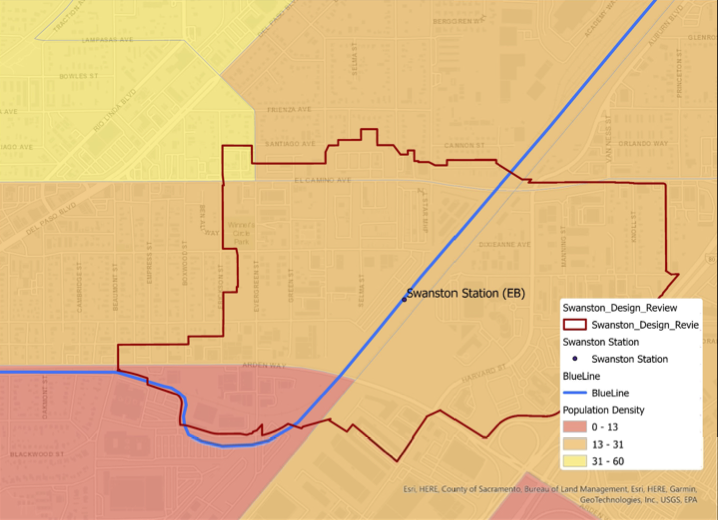
The population density northwest of Swanston Station is below average for the county (pdf), but not very low. There are certainly much lower density areas, including Woodlake just to the southwest. Of course the purpose of creating a transit village is to increase density, but starting at a low level, with all the infrastructure and construction costs, may not be an efficient approach.
If we invested a lot of money around Swanston Station, for infrastructure upgrades, street improvements (most streets have no or poor sidewalks), affordable housing and market rate housing, inducements to neighborhood serving businesses, this could indeed become a transit oriented development. I don’t have an estimate of the cost, and the plan did not estimate, but I would guess somewhere between $200M and $600M. Who has that kind of funds? Are there better places to invest?
Future posts will identify transit accessible places that have already had development, or have active development proposals. Transit oriented development is a good idea, but we must be very selective about the places we choose.
