More detail on each bus stop has been compiled and added to the table in the previous post. The ‘shared b/b’ column indicates the width of the shared bus stop and bike lane at these stops. The area will be painted with dashed green bike lane markings. You may need to scroll right to view the entire table. If that doesn’t work, a pdf version is available.
| Stop ID | Route | direction | cross-street | location | bench | shelter | trash | BCS | shared b/b | phase | note |
| 1772 | 11 | eb | 5th St | before | after | 15 feet | Phase 1 | ||||
| new | 11 | eb | Muir Way | none | before | 15 feet | Phase 1 | ||||
| 128 | 51, 51X, 11 | eb | 10th St | before | remove | ||||||
| 227 | 51, 51X | eb | Riverside | after | X | X | no change | 14 feet | Phase 1 | ||
| 229 | 51, 51X | eb | 15th St | before | X | no change | 15 feet | Phase 1 | |||
| 231 | 51, 51X | eb | 18th St | after | before | 14 feet | Phase 1 | extension follows | |||
| 232 | 51, 51X | eb | 19th St | after | X | X | X | no change | unknown | Phase 3 | |
| 233 | 51 | eb | 21st St | after | X | no change | unknown | Phase 3 | |||
| 234 | 51 | eb | 24th St | after | X | X | no change | unknown | Phase 2 | ||
| 1918 | 51 | wb | 24th St | after | no change | 15 feet | Phase 1 | ||||
| 1919 | 51 | wb | 22nd St | after | X | X | X | no change | 13 feet | Phase 1 | |
| 1920 | 51 | wb | 21st St | after | X | no change | unknown | Phase 3 | |||
| 1921 | 51 | wb | 19th St | before | no change | unknown | Phase 3 | ||||
| 1922 | 51, 51X | wb | 18th St | after | no change | 8 feet | Phase 1 | extended curb | |||
| 1924 | 51, 51X | wb | 15th St | after | no change | 15 feet | Phase 1 | ||||
| 1925 | 51 | wb | 13th St | after | no change | 15 feet | Phase 1 | ||||
| 1926 | 51, 51X, 11 | wb | Riverside | after | X | no change | 9 feet | Phase 1 | |||
| 1940 | 51, 51X, 11 | wb | 10th St | after | no change | 9 feet | Phase 1 | ||||
| 1770 | 11 | wb | 8th St | after | no change | 15 feet | Phase 1 | ||||
| 1771 | 11 | wb | 6th St | before | X | X | no change | 15 feet | Phase 1 |
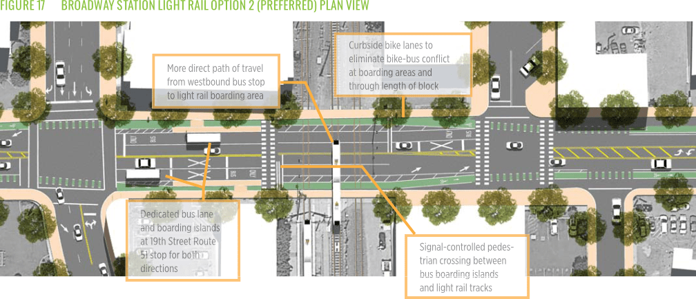
We have clarification from city staff about why the design for 19th Street, west side, to 21st Street, east side, is missing from the design document. The city is still negotiating with Union Pacific (UP) and the California Public Utilities Commission (CPUC). CPUC controls the light rail tracks and crossing, and UP controls the freight tracks and crossing. This part of the Broadway Complete Streets project will be part of ‘phase 3’ following the formal Phase 2 which covers 24th Street to 29th Street. The city says if has funding for the missing part.
Since this section was missing, we looked back at the 2016 Broadway Complete Streets plan, which has the following diagram for this section. It is uncertain, and perhaps unlikely, that the final design will look like this diagram. Still, it is interesting because it is the only location on Broadway where bus boarding islands were specified, for the Route 51 bus stops both eastbound and westbound, between 19th Street and the tracks, with the bike lane passing behind the bus boarding island. This design of bus boarding island with bike lane behind is best practice, and used in many locations in other cities.