City of Sacramento is updating its general plan to 2040. Several changes to the draft have improved support for transit. Between guidance provided by city council for the General Plan update and the current draft, there was a swing to less progressive and impactful language in the General Plan, but with the latest draft, there is a swing back. Many of these changes first showed up in the Missing Middle Housing Program plan.
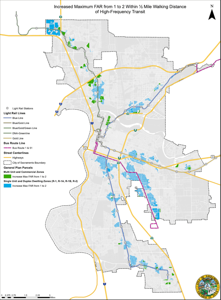
The most significant change for transit is that the distance from high frequency transit (15 minutes or better during the main portion of the day) was increased from 1/4 mile to 1/2 mile walking distance, and the FAR (floor area ratio) limit was increased from 1 to 2. Of these two changes, the expansion to 1/2 mile may be the more significant in the long run. Transit needs some density of residents in order to be successful, and much of the city is below that density. Of course the general plan only allows this density, it will be up to developers with support from the city to actually accomplish this density. There is no standard measure of density necessary, because the success of a transit system depends on the entire transit network, not on one particular location. However, this transit-supportive change is a great step forward.
Of course the next step will be to identify additional corridors for high frequency transit. Currently only light rail, route 51 Stockton, and route 1 Greenback (only a tiny fraction of which is in the city) are high frequency routes. SacRT accomplishes 15 minute frequency on a portion of routes 30/38 by overlapping them. Route 81 is 15 minute frequency for a small portion of the day.
The revised language includes:
“LUP-4.1 Transit-Supportive Development. City shall encourage increased residential and commercial development intensity within ½ -mile one-quarter of existing high-frequency bus stops and existing and planned light rail stations and, commuter rail stations, and high-frequency bus stops to support more frequent, reliable transit service and vibrant, walkable neighborhoods.“
“LUP-A.6 Future High-Frequency Transit Routes. The City shall reevaluate land use designations and maximum development intensities as new high-frequency transit routes are established by transit agencies, including the Sacramento Regional Transit Agency (SacRT), Sacramento Area Council of Governments (SACOG), and San Joaquin Regional Rail Commission.“
The other important change shows up in a map description, not in the GP language:
“Map LUP-6 (Maximum FAR) Staff is recommending increasing the maximum FAR from 1 to 2, for parcels within ½-mile walking distance of high-frequency transit stops. Maximum FAR standards for approximately 17,000 parcels have been updated to allow higher development intensity standards and support a greater array of housing types near high-frequency transit. These updates were made as a result of extensive public support for this change.“
The map (pdf) below shows these newly supportive areas, for two zoning categories, multi-unit and commercial zones, and ‘The map (pdf) below shows these newly supportive areas, for two zoning categories, ‘Multi Unit and Commercial Zones’, and ‘Single Unit and Duplex Dwelling Zones (R-1, R-1A, R-1B, R-2)’. Note that there are many areas that were not increased because they were already at FAR 2 or above due to other zoning categories. The second map shows the FAR for the entire city, with much larger areas along transit corridors at FAR 2 or above. A map that combines exist proposed areas of FAR 2 or above with the newly added areas of FAR 2 is not part of the General Plan update.