Note: Other Truxel Bridge posts are available under category ‘Truxel Bridge‘.
There is no question that the American River constrains travel between the northern part of the city and the southern. There are motor vehicle bridges at Interstate 5, California Hwy 160, Business 80, H Street/Fair Oaks Blvd, Howe Avenue, and Watt Avenue (at the eastern edge of the city). There are railroad bridges just east of Hwy 160 and just west of Business 80. Light rail runs on the Hwy 160 bridge, a single track which means it is a pinch point. There is a walking and bicycling bridge, Guy West Bridge, at Sac State. The biggest gap in river crossings is outside the city, between Watt Avenue and Sunrise Blvd, 9-1/2 miles, depending on how you measure it.
The city’s American River Crossing Alternatives Study Summary Report 2013 focuses on the area between the confluence of the American River and Sacramento River, and the Hwy 160 bridge. A diagram of the alternatives considered is below.
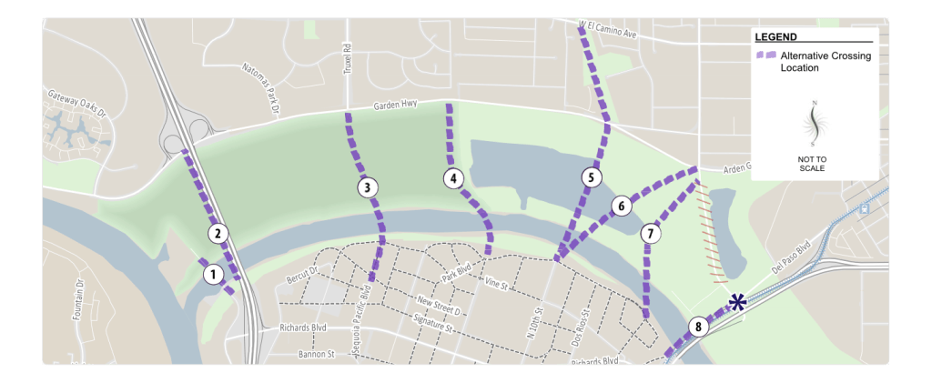
The study rejected alternatives 1, 2, 4, 5, 6, and 7. Alternative 8, using the existing Hwy 160 bridge corridor, was looked at more favorably, but alternative 3 was selected. It is the alignment proposed for the Green Line Light Rail, from downtown to at least south Natomas, and eventually to the airport, so it makes sense to select this alignment for that purpose. However, unless it also carries motor vehicle traffic, as the city has proposed, it is useless for circulation other than transit. Though the study is not explicit, part of the reason for rejecting alternative 8 is that of the two bridges that carry Hwy 160 over the river, one is due for replacement. The city seems uninterested in replacing that bridge, perhaps due to the expense. Though Northgate Blvd connects to Hwy 160 north of the river, it is in the river floodplain and is closed by flooding in some years, so it would have to be elevated to avoid this, another expense. The city’s estimate is that alternative 8 would cost about three times as much as alternative 3, however, this includes complete replacement of the Hwy 160 bridges, elevation of Northgate Blvd, and well as an interchange/intersection between Hwy 160 and Northgate Blvd. But these are useful projects in and of themselves.
Some people have recommended Northgate Blvd as an light rail and/or transit alternative to Truxel. Truxel has more residents and more commercial areas whereas Northgate is some residential and much warehouse. Northgate does not extend north of Del Paso Rd, but then Truxel Rd/Natomas Blvd does not extend north of Elkhorn Blvd. If light rail is to extend to the airport, the Truxel alignment makes somewhat more sense, but STAR has doubts about light rail every going to the airport. Another post will focus on that question.
One or both of the Hwy 160 bridges will eventually need to be replaced. So far as we are aware, the city does not have any active plan nor grant applications for replacing that bridge. That the city is selecting a new bridge on the Truxel alignment rather than replacement and use of an existing bridge on Hwy 160, and connection to Northgate Blvd, seems the result of incomplete analysis and rushed decision making.
It would be valuable to have additional routes between north and south of the American River. But there is always a tension between motor vehicle trips and transit trips. Easing motor vehicle trips reduces transit, walking, and bicycling trips. That is a fact. So the city’s effort to increase motor vehicle circulation will reduce other trips. Whether the new route for transit, walking and bicycling will also increase these trips is assumed by the city, but is doubtful. For most people, if they can drive, they will, and making their trips easier will encourage them to drive.
The savings in travel distance for the Truxel Bridge versus traveling a distance on I-5, either from West El Camino to Richards Blvd, or Garden Hwy to Richards Blvd, is only about one mile. Of course if the freeway is congested, and the new route is not, this could mean some significant time savings. But under normal travel conditions, the savings is negligible, as most trips from Natomas to downtown are six miles or more.
Next up, current transit service between Natomas an downtown.

It’d be great if the city made this new bridge a transit/ped only bridge like the Tilikum crossing in Portland. I’m sure local pols would love the opportunity to stamp their name onto something like that.
LikeLike
The original bridge proposal was for transit, walking and bicycling, only. The city proposal to add motor vehicles different.
LikeLike