SacRT’s Green Line to the Airport webpage provides some resources describing the Green Line project. Most of the information below is summarized from the Transitional Analysis Report of 2010. Note that this is the last SacRT document available; there have been no additional documents for 13 years. Some minor adjustments were made to this proposal at the November 8, 2010 board meeting, to remove specification of local funding sources.
SACOG
The webpage links to the 2016 SACOG MTP/SCS, but the current version is 2020, and it is being updated now for completion in 2025. The 2020 version does not specifically refer to the Green Line, but does have references to light rail extension:
- In priority policy 4, ’Build and maintain a safe, resilient, and multimodal transportation system’, “The other $2 billion of capacity increases will go to large transit capital expansion projects such as extending light rail to Natomas, improving heavy rail service into Placer County, or other infrastructure investments to facilitate enhanced bus service like Bus Rapid Transit.“
- POLICY 19: Transit expansion, particularly light rail and other fixed infrastructure transit options, should be targeted at communities with supportive land use policies and development patterns that will generate transit ridership and improve the cost recovery rates for transit service.
- Green Line to the Airport is not in the 2023 MTP (Metropolitan Transportation Plan), so SacRT has not requested any funding to further planning or design of the Green Line.
Route
The proposed alignment of the Green Line is shown on the map below (pdf). Note that this is the second version of STAR’s map. It reflects that North Natomas Town Center station is one of the potential terminus points, rather than East Town Center station which is deferred, and Gateway Park Blvd station is another potential terminus. Though planning does not identify it, STAR is including San Juan Road station as another potential terminus.
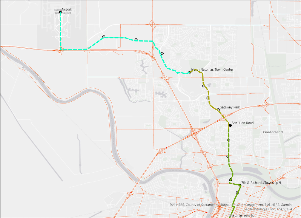
Truxel Road and Natomas Blvd, from Garden Highway on the south, to New Market Drive on the north, varies considerably in width. For some sections, fitting in light rail or bus rapid transit (BRT) would be easy. For other sections, not as easy. There is no on-street parking along any of this 3.8 mile segment. From San Juan Road to New Market Drive, there are intermittent medians, some with trees.
From Garden Highway to San Juan Road, including West El Camino Blvd, the roadway is generally four lanes, with bike lanes and sidewalks. The proposed route would be center running, double light rail tracks, shared with left turn lanes in some locations, but otherwise in its own right-of-way. The roadway width is commonly 90 feet, but with flare-outs for multiple turn lanes at intersections with West El Camino and San Juan Road.
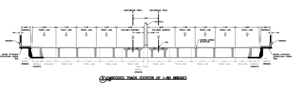
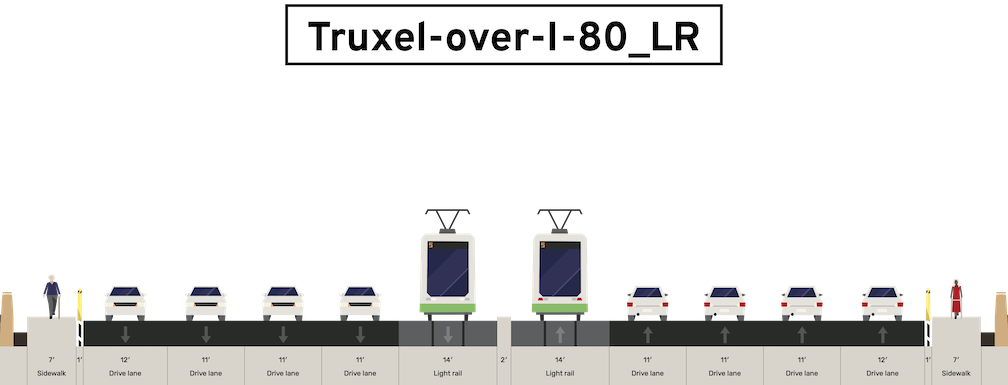
From San Juan Road to Gateway Park Blvd, Truxel passes over Interstate 80. The intersection with Gateway Park is ridiculously wide, eight lanes northbound and four southbound on the south side of the intersection. For that that reason, and that the intersection is often congested, the proposal is for an elevated light rail station above, or north or south sides beyond the intersection, not at the surface roadway level. Light rail would return to surface after the station. It is because of the expense of widening the bridge over I-80 to accommodate light rail, and the expensive elevated station and bridge for Gateway Park Blvd, that STAR feels a terminus at San Juan Road should be considered. The Transitional Analysis Report offers a diagram of light rail on the over-crossing of I-80, first below, but it is a low resolution bit image with the measurements unreadable, so STAR has made a similar diagram, second below. The widths are estimated and may be incorrect. The over-crossing would need to be widened by about 14 feet in order to carry light rail, unless one or more general purpose motor vehicle lanes were eliminated.
From Gateway Park Blvd north to New Market Drive, light rail would be on the west side of the roadway, not center-running. Apparently there is right of way reserved for this, though it is not clear that it has been maintained everywhere.
At New Market Drive, the route would turn west to a North Natomas Town Center station. There is a wide median strip of 36 feet or more on New Market, intended to accommodate light rail. This summary does not go beyond North Natomas Town Center station, but there are a potential of three additional stations plus the airport station.
The report mentions single-tracking some pieces of the route, mostly to reduce costs but also to reduce right-of-way impacts in some locations. STAR is concerned about any single-tracking of light rail in any location on any light rail line, because these can become pinch points that stop or slow service in case of problems such as stalled trains or traffic crashes, and probably would preclude service ever becoming more frequent than 15 minutes.
Bus
The Transitional Analysis Report offers a redesign of the bus network in Natomas, to complement light rail. However, this was prior to the SacRT Forward system redesign in 2019, so it would likely be different if planned today. Interestingly, the report offers an interim ‘baseline alternative’ bus route along the same light rail alignment, except using I-5 to cross the American River rather than a new bridge, and using existing roads between Natomas and the airport. But this option is not detailed. bus service to Sacramento airport and Truxel Bridge and bus transit offer more information about existing bus service to the airport and in Natomas.
Justification
The report details ridership projections under various build and operational scenarios, and calculates Tranportation System User Benefits (TSUB) and Cost Effectiveness Index (CEI) which FTA (Federal Transit Administration) uses to judge the usefulness of a project. STAR does not have the expertise to evaluate SacRT’s analysis. We are concerned that the projections may be overly optimistic, given that ridership on the SacRT Route 142 Airport and Yolobus 42A/42B segments which serve the airport are relatively low.
Cost
The cost of the full route to the airport was estimated in 2010 to be about $900,000. In the last 13 years, costs have escalated both due to inflation, and the expense of major infrastructure projects. STAR estimates that the project could be $1.5B by the time of construction, and could easily be $2B. That alone is justification for considering a shorter route with terminus points at San Juan Road, Gateway Park Blvd, or North Natomas Town Center, and the report does some analysis of the savings from other terminus points (though not San Juan Road).
The report assumes a new sales tax measure passing in 2012. The measure was not on the ballot until 2016, and failed, and did not allocate that much money to the Green Line. A measure was pulled in 2020, and a measure in 2022 failed spectacularly. There is discussion of a transportation and housing measure in 2026, but it is unknown whether it would fund the Green Line. The report also assumes a New Starts application and award from FTA, but no application has been submitted.
Next
STAR hopes that this summary information on the Green Line is useful to you. It is also supporting information for the question: light rail or bus rapid transit?
