The City of Sacrament opened an online community questionnaire on the Truxel Bridge project. The video on the questionnaire page reiterates that the city is not seeking comments on the need for the bridge, but just the details of the alignment and cross-section. If you haven’t, please read the city’s Truxel Bridge Concept and Feasibility Study page first. Answers are due by February 26, two weeks from today.
STAR has offered seven previous posts on Truxel Bridge, also worth reading.
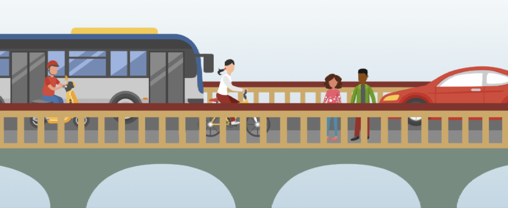
An interesting illustration was used in the email announcing the questionnaire. It show a bus, not a light rail vehicle. Does this signify something, or it just a random illustration included without thought about what it shows?
In case you wish to view the questionnaire before completing it, it is offered below, and as pdf. This is the same set of questions that were asked at the community meeting on January 10. At this meeting, a significant portion of the audience express dissatisfaction with the questions being asked, noticing that any feedback about the need for, or location of, the bridge was being rejected. Concerns about the impact on the American River Parkway were discounted. It was not a positive meeting.
1. What is your zip code?
- 95811
- 95833
- 95834
- 95835
- 95815
- Other (please specify)
2. How often do you travel between north Sacramento (including north and/or south Natomas) to downtown across the lower American River?
- Every day
- More than once a week
- Once a week
- Less than once a week
- Never
3. What travel modes do you currently use to travel between north Sacramento (including north and/or south Natomas) and downtown/midtown?
- Public transit
- Bicycle/scooter/skateboard
- Walking
- Automobile
- Other (please specify)
4. What is the purpose of your travel between north Sacramento (including north and/or south Natomas) and downtown/midtown?
- Job
- Entertainment
- Shopping
- School
- Medical Appointments
- Other (please specify)
5. Please share your thoughts on what benefits you and/or others in your community would receive from a bridge that accommodates all modes of travel (automobiles, transit, bicycle and walking) between north Sacramento and downtown/midtown across the lower American River?
- More travel options such as walking, cycling or using transit
- More direct and faster route
- Better emergency access
- Avoiding traffic congestion on I-5
- I don’t see any benefits
- Other (please specify)
6. What concerns might you currently have with a future Truxel Bridge?
- Ensuring that bicyclist and pedestrians have a safe traveling experience
- Ensure that there is enough space for any emergencies on the bridge
- Potential environmental impacts to the American River Parkway
- Potential cut-through traffic in adjacent neighborhoods
- Cost of the bridge
- I don’t have any concerns
- Other (please specify)
7. How would having a bridge that accommodates all modes of travel change current travel patterns?
- More people would walk or bike
- More people would take transit
- More people would drive
- Less people would walk or bike
- Less people would take transit
- Less people would drive
- No change
- Other (please specify)
8. Please share what you like and what concerns you have about each bridge concept.
Option A: Mixed Use Travel Lanes with Trail Connection
| Pros | Cons |
| Narrowest cross section and smallest footprint Lowest cost Less impact to nearby buildings on Sequoia Pacific Blvd Center median for emergency vehicles Shoulders for vehicle breakdowns Accommodates Class II bike lanes and a Class I trail* Allows for Jedediah Smith trail connection Mixed-use lanes will help control the speed of traffic Physical barriers separate pedesrians and Class I bikes from vehicles | Mixed-use lanes may be uncomfortable for some drivers Pedestrians are not fully separated from bikes Potential transit delays associated with shared lanes |
*Note: Class II bike lanes include a portion of the roadway that is striped for one-way bike travel, while Class I bike trails are fully separated bike facilities, exclusively for the use of bicyclists and pedestrians.
8a. What do you like about Option A?
8b. What concerns do you have about Option A?
Option B: Separated Transit with Trail Connection
| Pros | Cons |
| All modes of travel are separated Allows for Jedediah Smith trail connection Reduced shoulders and narrower lanes will help to control vehicle speeds | Emergency vehicles will have to use bike path or transit lanes for access Vehicle breakdowns will impede traffic due to the reduced shoulder space No physical barrier separating pedestrians and bikes from vehicles Additional wait time at the Richards Blvd/Truxel Rd and Truxel Rd/Garden Highway intersections due to separate light rail signal timing. |
8c. What do you like about Option B?
8d. What concerns do you have about Option B?
Option C: Sacramento RT Green Line
| Pros | Cons |
| All modes and directions of travel are separated Reduced shoulders and narrower lanes will help to control vehicle speeds | One directional bike lane provides limited connectivity to Jedediah Smith Trail Widest cross-section Most expensive Bike lane is the only space available for emergency access/vehicle breakdowns No physical barrier separating pedestrians and bikes from vehicles |
8e. What do you like about Option C?
8f. What concerns do you have about Option C?
9. Do you have any other questions or comments about Truxel Bridge?
10. If you would like to sign up for project updates about Truxel Bridge, submit your email address below.

One thought on “Truxel Bridge online community questionnaire”