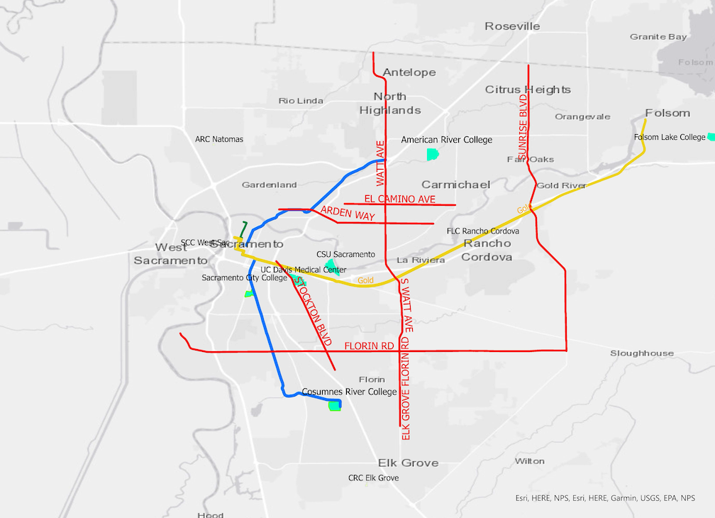
As promised in the add routes to High Capacity Bus Study, here are maps on SacRT routes selected in the High Capacity Bus Service Study (red), and additional routes suggested by STAR.
First, similar to the map in the study, which shows high capacity bus service which should be studied further and perhaps planned. Existing light rail lines (Gold, Blue, Green, in their traditional colors) are shown for context. pdf
An important concept provided by Jarrett Walker in Human Transit: If a regular bus is very popular (high ridership and important destinations), consider bus rapid transit (BRT). If that BRT is very popular, consider light rail. STAR does not feel it is appropriate to jump straight to light rail where there is no bus service with demonstrated high ridership. The only light rail extension that currently has high ridership is the section of SacRT Route 1 Greenback between Watt/I-80 station and American River College (ARC). The other extensions do not.
The value of a high capacity route is not just the number of riders served (which depends in part on the residential density surrounding the route), but also the important destinations served, and the connections to other high capacity routes.
Stockton Blvd: STAR support BRT along Stockton Blvd, though the project negotiated between SacRT and the City of Sacramento will likely fall well short of true BRT. See Ride the Future: Sacramento’s Bus Rapid Transit Solution. The new plan, which updates the transit element of the Stockton Blvd Corridor Plan (2021-04) and SacRT’s Stockton Blvd Implementation Plan (2023-07), is not yet available.
Watt Ave: Though it is clear that Watt Avenue between Folsom Blvd (Watt/Manlove light rail station) and Roseville Road (north of Watt/I-80 light rail station) would be of high value, it is not clear that service north of Roseville Road or south of Folsom Blvd deserves a high level of service.
Sunset Blvd: Though Sunset Blvd carries a lot of motor vehicle traffic, and has excess roadway width over most of its length, it is not clear that it justifies a high level of service. SacRT Route 21, which serves part of this section, is not heavily used in this section. Service south of Auburn Blvd is particularly questionable.
STAR feels that higher education campuses should be located such that they can receive frequent service, and that they should be served. Therefore, these were added to the map:
- Sacramento State (served inefficiently by Blue Line 65th Street Station, would be served by SacState to West Sacramento BRT)
- UC Davis Medical Center (currently served by SacRT Route 51 Stockton, and will be served by Stockton BRT)
- American River College (would be served by Blue Line ARC extension and/or Greenback BRT), including Natomas Center (would be served by Natomas BRT)
- Sacramento City College (served by Blue Line City College Station), including West Sacramento Center (would be served by Sac State to West Sacramento BRT)
- Cosumnes River College (served by Blue Line CRC Station), including Elk Grove Center (would be served by Elk Grove BRT or light rail extension)
- Folsom Lake College (not served) including Rancho Cordova Center (served by Gold Line Mather/Mill Station). Folsom Lake College was located in an area unlikely to ever see high capacity service.
The college centers (FLC Rancho Cordova, CRC Elk Grove, ARC Natomas, SCC West Sacramento) are too small to show as polygons on this scale map, but labels provide approximate locations.
Second, a map showing all the routes that STAR feels should be considered in a comprehensive study of high capacity service. This is a complicated map, so explanations of each route follow. pdf

This map shows the existing SacRT Route 142 (orange), which serves the airport from downtown Sacramento. It is a low frequency route, 60 minutes, with a service span from 5:15 AM to 10:30 PM. It is shown because it could be turned into a high frequency route with funding, and dedicated space on Interstate 5 between downtown and the airport. A shoulder bus lane has been proposed by Caltrans in their capacity expansion of Interstate 5, but that project is not funded (though Caltrans is doing part of that project with maintenance funds, illegally).
Light rail extensions
Green Line to the Airport extension (green dashed): This would extend Green Line light rail from Richards Blvd/Township 9 to Sacramento International Airport (and which would interline with the Gold Line), has been politically popular, but is doubtful from a ridership and funding perspective. The currently proposed alignment would use a new bridge over the American River, the Truxel Bridge, which has been a source of controversy both for its effect on the parkway, and the city’s insistence that the bridge include private motor vehicles. See earlier posts under category Green Line to the Airport.
Blue Line to Elk Grove extension (blue dashed). This would extend Blue Line light rail from Cosumnes River College (CRC) south to some part of Elk Grove. Elk Grove is a moderate density city, which justifies bus service but may not justify high capacity service, but many areas within the city limits are low density or undeveloped, which does not justify any service let alone high capacity. See earlier posts Blue Line or BRT to Elk Grove and more on Blue Line/BRT to Elk Grove.
Blue Line to ARC and northeast (blue dashed): This would extend Blue Line light rail from Watt/I-80 to American River College (ARC), and perhaps further to Citrus Heights and Roseville. STAR feels that the extension to ARC is the highest value light rail extension, but again, recommending that it be considered with all other high capacity routes. It is less clear that light rail extension from ARC to Citrus Heights and Roseville are high value. See light rail to American River College and light rail beyond American River College.
High Capacity BRT routes
In addition to the routes proposed in the High Capacity Bus Service Study, STAR suggests several additional routes that may have as high or higher value that those proposed in the study.
Greenback BRT (pink): BRT along the existing SacRT Route 1 Greenback from Watt/I-80 to ARC to Greenback and Sunrise in Citrus Height might serve better than light rail. Auburn Blvd has excess capacity, as does Greenback Avenue.
Natomas BRT (pink): This BRT route would duplicate SacRT Route 11 from downtown to Del Paso Blvd in North Natomas. If a Truxel Bridge is built, it would use that bridge, however, the detour to Interstate 5 between Richards Blvd and Garden Hwy would not add significantly to the run time of this route. The city council representives for North Natomas (Lisa Kaplan) and South Natomas (Karina Talamantes) have both supported BRT to Natomas. This BRT route was excluded from the study because it assumed that light rail would be built instead, but that looks increasingly doubtful. The section of Truxel Road between San Juan Road and Del Paso Road already has right-of-way reserved for transit.
Elk Grove BRT: BRT could be provided along the route suggested in the ongoing Blue Line/BRT to Elk Grove Implementation Plan project, at least as far as Whitelock Road. This is not shown separately on the map because the route would like be very similar to the light rail extension.
Sac State to West Sacramento BRT (pink): This is a route recently suggested to STAR by a transit supporter. Sac State (CSU Sacramento) is a major traffic generator which is inefficiently served by Gold Line light rail at 65th Street station, and several bus routes to the campus. A BRT route between Sac State and downtown Sacramento would likely be heavily used. In West Sacramento, Yolobus Route 240 and Route 42A/B serve Capitol Avenue, and 240 also serves the major shopping center Riverpoint Marketplace with Ikea and other stores. Combining these two existing routes into a single BRT route would likely serve a great number of riders. It is not clear whether the route would serve Sacramento Valley Station, as does the current Route 30/38, or would take a more direct route, so the map shows both routes separately.
Your comments on these ideas are welcome. STAR believes that there should be a comprehensive look at all possible routes and extensions in order to determine which ones should move forward in the nearer term, put on the back burner, or eliminated. Once those decisions are made, then a more in-depth look at each route should be undertaken. This is being done for Stockton Blvd and the Elk Grove Blue Line/BRT study, but without a comprehensive look at all potentials, these projects are jumping the gun. It is time for a Long Range Transit Plan that studies and prioritizes all of these routes.
